Lake Chelan Magazine
“This region is Disneyland for geology,” says Nick Zentner, internet sensation and the star of the hit public television series Nick on the Rocks. A professor at Central Washington University, Nick teaches geology smack dab in the middle of hay country. I came to talk with him about the formation of Lake Chelan, just 135 miles northeast from the university.
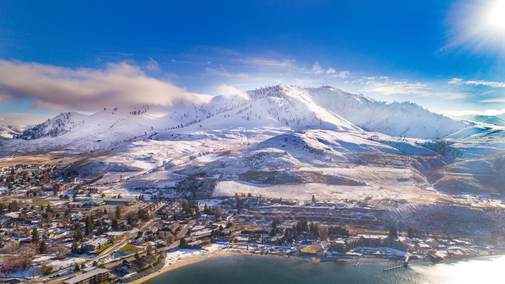
Lake Chelan is located where the North Cascades mountain range meets the arid steppes of eastern Washington. It’s the third deepest lake in the country, following Crater Lake in Oregon and Lake Tahoe in Nevada. It’s so deep — 1,459 feet deep — it plunges hundreds of feet below sea level. Fifty miles long and a mile across, the lake is a playground for tourists from Seattle, who enjoy its crystal blue water, sunshine, and adjacent wineries.
But Lake Chelan’s origin story, according to Nick, is an ice-age battle that’s far more complex than most visitors or residents imagine.
I met Nick in his office on campus. He has a habit of tilting far back in his chair while he talks, camouflaging his height until he unfolds to stand, six foot five, a bulky man in khakis and a fleece Patagonia vest over his button-down shirt. Next to his charts and maps, a bright red gum-ball machine sits on the windowsill. It seems out of place, until you notice it’s packed tight with small polished stones.
Candy and rocks. The juxtaposition makes sense as Nick begins to talk. He has a penchant for food analogies. He calls it his “sweet spot,” the balance between detail and storytelling, that aha moment when people with little or no understanding of geology catch a glimmer of the earth’s history.
People feel a deep connection to physical places, Nick explains, “like that ridge where they stop each October to buy cider. It’s almost like I’m telling stories about a family member. Add science, and it develops momentum of its own.”
While most people guess Lake Chelan was formed by a glacier, he says, the story is more complex. First there is a bedrock story. From before the times of dinosaurs, ancient rocks called migmatite — which look a little like swirled chocolate and vanilla soft-serve ice cream — pushed to the surface along the lakeshore.
The second story is an ice age story. There was no lake before that time, says Nick, not until two competing arms of ice fought it out in a duel and carved the body of water.
Two competing arms?
“Yes, one coming from each end of the lake.”
It’s an almost outrageous supposition, a little too much coincidence, but to borrow one of Nick’s gourmand phrases, the proof is in the pudding.
For those who remember Geology 101, a mountain lake is often formed by an alpine glacier, or a little ribbon or finger of ice, coming down a mountain valley. The glacier carries rock debris with it and drops the stones at its edges. This creates a ridge of loose glacial rocks called a moraine. When the glacial ice melts, water fills the space within the moraine and forms a lake.
But Nick says evidence suggests a different origin for Lake Chelan, beginning with the Canadian ice sheet. During the ice age, it covered what’s now Canada and stretched south to central Washington and across the northern United States. The ice was a mile thick as it invaded the North Cascades. It flowed slowly like congealed honey or taffy, so massive and heavy it literally crossed mountain ridges. Ice funneled into valleys and rounded off mountain peaks as it plowed the lower basin of Lake Chelan from the south.
From the north end of the lake, aerial views of the North Cascades show typical u-shaped valleys with alpine glaciers and razor-sharp ridges carved from glaciers. Photos and video also reveal numerous ridges that look as if they have been beveled off, evidence of the ice sheet’s multiple advances and retreats over two and a half million years.
One arm of this ice sheet, suggests Nick, masqueraded as an alpine glacier. It flowed through a low spot now named Rainy Pass and found its way to the Chelan Valley, where it formed the upper basin of Lake Chelan.
“Rocks tell the story,” says Nick.
The rocks along the upper two thirds of the lake, above a section called The Narrows, are predominantly gneiss. That’s a common metamorphic rock with a banded texture of alternating darker and lighter-colored bands. While that same rock is found throughout the North Cascades mountains to the west, it is surprisingly scarce on the lower end of Lake Chelan. You’d expect to find loads of it there, says Nick, if the lake was created by one alpine glacier.
Instead, at the lower end of the lake, geologists find flood basalt, just like they find to the east, across the Columbia River, on the basaltic plains of the Waterville plateau. The Okanogan ice sheet carried hundreds of huge brown haystack rocks there and dropped them like milk duds, says Nick.
Thousands of similar basalt boulders are scattered across tawny hills above the lower part of Lake Chelan. Like the haystack rocks, they’re remnants from the Okanogan lobe, which last flowed through the valley 15,000 years ago. In contrast, you won’t find basalt bedrock in the North Cascades.
In addition, the town of Chelan at the southern end of the lake sits on 400 feet of loose glacial rock that matches Columbia bedrock from Eastern Washington. Geologists and hikers find the same type of rocks, called glacial till, scattered loose like German chocolate cake along the tops of the ridges above Chelan.
The whole area screams glacial activity, says Nick, pointing to a photo of sculpted rock faces that look like someone dragged their fingers along a cube of butter. “You can’t ignore the evidence. The unique types of rock at either end of the lake support the idea that a second lobe of the ice sheet flowed through from the east and dug the lower basin of Lake Chelan.”
But what about The Narrows, the deepest part of the lake, where Nick proposes the two competing arms of ice sheet met? Interestingly, geologists find a third type of rock there, neither gneiss nor basalt, but schist. Schist is another metamorphic rock, but one that is typically softer. That would explain why the ice sheets were able to plow so much deeper in that section, 386 feet below sea level, says Nick.
The formation of Lake Chelan is an ancient story of two glaciers in a head-on collision, he concludes. It turned what would have been an eastern Cascade river valley into one of the most beautiful and deepest lakes in North America.
